As the oil and gas sector continues to shift to a more digital way of thinking and the ‘digital oil field’ becomes an ever buzzier buzz-phrase in industry circles, offshore operations are becoming increasingly reliant on huge reams of virtual data. The immediate availability of relevant information, and the ability to quickly push that information to the right people, plays a central role in the whole offshore operational process, from initial exploration and survey work, through risk analysis and asset management to the complex workflows involved in maintaining steady production.
Go deeper with GlobalData

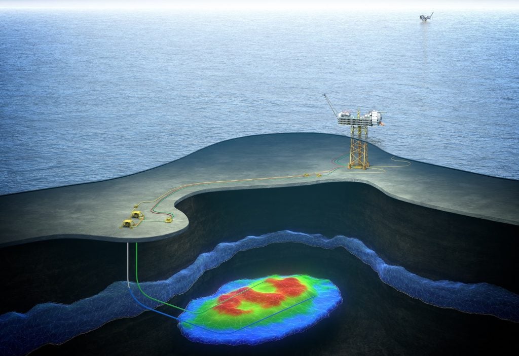
In an industry as physical and geographically specific as offshore oil and gas, the presentation of this data is evolving with the use of geographic information systems (GIS). This technology is used to tie diverse geospatial data sets into mapping software, allowing a geographic overview that places information in its proper physical context. In simple terms, it’s a lot more useful to look at data on a map than a spreadsheet.
"What’s always said is that 80% of data within energy companies has a spatial component, and it’s certainly very true for the oil and gas sector," says Paul Edmunds, CEO of GIS specialist Island GIS, which offers GIS services to offshore oil and gas operators such as Cairn Energy, Maersk Oil and Petroceltic (formerly Melrose Resources), as well as clients in other sectors.
"GIS information acts as a management tool to bring all that information together, so you can make much better-informed decisions, which you pretty much can’t do without looking at it on a map and then putting it into a database, which enables you to do additional analysis."
See Also:
GIS: a response to industry challenges
GIS and geospatial data management as a whole has become increasingly embedded in the oil and gas landscape, partly because it helps mitigate some of the 21st century challenges the industry is facing.
How well do you really know your competitors?
Access the most comprehensive Company Profiles on the market, powered by GlobalData. Save hours of research. Gain competitive edge.

Thank you!
Your download email will arrive shortly
Not ready to buy yet? Download a free sample
We are confident about the unique quality of our Company Profiles. However, we want you to make the most beneficial decision for your business, so we offer a free sample that you can download by submitting the below form
By GlobalDataWith operators venturing into new areas for exploration activities, GIS offers mapping and spatial information to bring insight on a region’s balance of potential and risk. And with the industry’s skills shortage starting to bite, integrated digital technologies are helping the industry do more with less.
"As there’s more and more exploration going on, those specific skills are going to be less and less [available], so having access to remotely sourced information and directing it to the right people more quickly and more efficiently is going to become more relevant," says Edmunds.
The now-common need to stray further offshore and into deeper and more environmentally-sensitive waters also presents challenges that can be addressed with smart GIS strategies. "Obviously the price of oil has a very strong impact on how far away from land, or how deep you can go," Edmunds says.
"But the geo-technology helps you make those decisions with simple distance calculations that can fit into financial plans. But then, if you are operating in those regions, you’re going to be more remote so it takes longer to travel to. So it’s things like remote operations management, visualisation tools and mapping technology; anything that’s going to help reduce the number of trips to the location."
Benefits of geographic information systems
Perhaps the clearest advantage of GIS technology is the ability to build layers of information into an easily digestible map format. For Edmunds, laying out information geographically is much more engaging and effective for users. "As long the information has a spatial component, you can overlay it. That’s the value, really – in a world of immense amounts of data that’s increasing, having a way to manage it is going to be vital. Most people, especially in the oil and gas industry, think spatially, so it’s important."
GIS also brings with it the advantages of the digital revolution, principally the ability for multiple project stakeholders to share a common data reference point. As large-scale projects tend to involve major partnerships, as well as dozens of contractors in the supply chain, there’s a pressing need for these shared portals.
"You’ve got more and more systems that are talking to each other, but it’s still a bit of a way off," Edmunds says. "With many of these operations, you’ve got multiple different stakeholders coming together with information, acquisitions are happening, so having all of this information in a form that’s easily transferable that you can integrate into a central portal, is hugely valuable."
From a risk management perspective, GIS presents particularly enticing cost-saving advantages. With vulnerable marine eco-systems like the Arctic now beginning to open up for exploration and drilling – not to mention tightening environmental legislation – managing spatial data gathered from environmental impact assessments has never been more vital.
"As there is more and more exploration in areas of the Arctic, having an understanding of temporal and seasonal ice changes is a core part of the planning procedure," says Edmunds. "Having all that information has huge cost implications; it’s essential to know that in relation to environmental impacts, from marine traffic to mammal movements and the different impacts they have. And also planning responses if something does happen, so you know exactly how to respond to that incident and you already have that. Every risk is considered, before a problem occurs. GIS is key to every aspect of that, it’s just overlaying on to a map rather than reading a document or looking at a spreadsheet."
The ‘Google advantage’
Island GIS distinguishes itself from many of its peers through a partnership with internet search giant Google, announced in August 2013. The company’s position as a Google GEO Enterprise Partner allows it to harness Google’s enviable geographic processing muscle to power its GIS services. Edmunds believes collaboration is a stepping stone to more advanced applications in the future.
"It’s been a fantastic and very exciting partnership that we’re developing," he says. "Working with a company like Google gives you access to a fantastic network of information on a global scale, platforms that are improving all the time. And because they’ve started as a sort of cloud-based delivery service with their solutions, we feel that they’re ahead of the curve at the moment in what they can do and very quickly improving their capabilities around their data."
With more powerful servers and a wider bandwidth to transfer data, the offshore GIS field and the ‘digital oil field’ concept as a whole is gradually moving towards a more sophisticated remote awareness of on-site platform operations in real-time, including video, sensors and image feeds – in a sense, the O&G sector’s very own Street View.
"Our focus is that it’s all about location, and tying that information together within a location, so with the likes of Google Street View, there you have a good example of tying imagery and mapping together," Edmunds says. "Those sorts of things in custom form for offline delivery can be hugely valuable when you’re setting up a wider GIS system to help understand and de-risk your operation."
Island GIS’s recent work for Cairn Energy gives an indication of the kinds of applications that could be refined and expanded in the future. The company set up an operations portal to integrate all GIS mapping data from drilling work, environmental reports and material assets in one place.
"We also integrated tracking information from fixed-wing aircraft and from all vessels – the rigs themselves and all the support vessels," Edmunds adds. "Those were tracked in near real-time so [Cairn] could get a live view on what was happening. That was successful across the company – there were different aspects of the business looking into that."
The exploitation of digital data is now a given in the offshore oil and gas industry, as in almost all other sectors. But as our understanding of that raw data improves with time, our ability to digest and visualise that data will develop in step.
Given the essential geospatial parameters of offshore E&P activities, innovations in GIS make a particularly good fit for giving operators a deeper, more nuanced and better-organised understanding of their increasingly complex operations.
.gif)
Related content
North Sea data reveals extent of oil and gas pollution
Mandatory reported data has revealed there are up to sixty spills a month happening in the North Sea alone.
Damage control: CAA announces offshore helicopter safety review
The UK Civil Aviation Authority (CAA) has announced a forensic review of offshore helicopter operations in the North Sea, following five accidents in the past four years.