
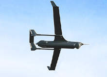
It looks inevitable that in the near future, unmanned aerial vehicles (UAV), which have already risen to high prominence in the military sector, will become standard tools in the commercial sphere as well.
Since the late 1980s research into UAVs has exploded the world over. Initially applications for the technology were largely military as they mostly operate outside of civilian airspace and do not have to comply with civil airspace standards and rules.
Go deeper with GlobalData

Discover B2B Marketing That Performs
Combine business intelligence and editorial excellence to reach engaged professionals across 36 leading media platforms.
The great benefits of removing the need for human pilots in air combat missions have also resulted in governments fast-tracking UAV use. The result is that leaps and bounds have been made in the efficiency, range, size and payload of UAVs, but regulation has meant that these developments have remained mostly outside the commercial sector.
This, however, is changing and the benefits of the technology are attracting the attention of the offshore oil and gas industries, which could benefit from using unmanned technology in remote areas to take over far-flung and dangerous missions.
Black gold
The advantages of using UAVs for offshore exploration are many, not only in terms of discovering new deposits but also for missions such as pipeline and facility monitoring.
Missions flown by manned fixed-wing aircraft are inherently dangerous due to the necessity of conducting such flights at low altitudes and air speeds over some of the world’s most hostile terrain, such as Antartica. UAV pilots, on the other hand, can be stationed safely on the ground.
Pilotless aircraft also offer an advantage as flights are not limited by the maximum time a pilot is allowed to fly, and missions can also be conducted at night, when instruments are often more accurate. Better still, UAVs are friendly to a company’s bottom line: cost.
Helicopters and light aircraft are maintenance-high platforms and therefore costly. UAVs are cheaper and require less investment to mobilise, set up, relocate and refuel.
Another feature of UAVs is their relatively low environmental footprint, which is a high priority for the offshore industry at present. UAVs present a much lower environmental impact as they require fewer materials to build, use less fuel, emit less pollution per distance travelled and are easier to dispose of at the end of their working lives.
Shell has also made use of UAVs to spot marine animals such as endangered whales and polar bears in an effort to protect them from exploration vessels in the Chukchi and Beaufort seas.
UAVs can be much smaller than regular exploration aircraft. This size difference can pose a significant advantage as the sensitive equipment used in exploration can often be affected by the magnetic or gravitational fields emitted by larger aircraft.
Strike it lucky
For a UAV to be useful in offshore exploration the aircraft must be able to travel at low altitude over long distances and carry a suitable payload of scientific equipment capable of storing and transmitting information.
The UAVs most suitable for this task belong to the medium-altitude, long-endurance or MALE category of UAV. Such aircraft are available in a wide range of sizes and shapes but are all capable of flying at an altitude of up to 30,000ft (9,000m) over a range of 200km.
The equipment commonly used for offshore oil exploration also comes in a variety of forms. The most popular include those that map landscape, including 3-D imaging using high-resolution cameras, and light detection and ranging (LIDAR), which uses optical remote sensing technology to produce very accurate terrain models.
The Australian Government uses a similar technology, D-VEX Digital Video from Mediaware, on board UAVs to explore the North West Shelf.
Seeing below the surface requires hyperspectral imaging using multiple images or a cesium magnetometer, which measures magnetic variations in the Earth. Gas sensing using a quantum cascade laser to detect minute amounts of ethane and other gases can also be used.
The GeoRanger, built by Insitu, is a long-endurance unmanned aircraft that carries a commercial magnetometer and can fly pre-programmed routes in excess of 15 hours. Data from the magnetometer sensor can be stored on board or sent to the ground control station.
The Integrator, also being built by Insitu, carries inertially stabilised electro-optical (EO), long-wave infrared (LWIR), and mid-wave infrared (MWIR) cameras with optional infrared marker and laser rangefinder to develop high-quality imagery used in terrain mapping and geomagnetic surveys.
UAVs with a heavier payload capability can also carry gamma ray mapping technology to quantify and describe the radioactivity of rocks and soils.
ElectroMagnetic (AEM) probing, which creates a visual display based on the field produced by electrically charged objects, is also available for larger UAVs such as the Hermes 1500 twin engine system built by Elbit Systems, which has a maximum take-off weight of 1,750kg.
The equally important task of pipeline monitoring is most often carried out using thermal imaging to detect the heat signatures caused by leakage in underground pipelines. Safety is also a crucial concern on the pipelines and a priority for companies such as Aeronautics, which uses Aerostar Tactical UAVs to patrol offshore oil fields day and night using forward looking infrared (FLIR) cameras.
Barriers – not cleared for take-off
By far the biggest barrier to routine commercial flight missions by unmanned craft is a lack of the regulatory guidance and standards necessary to allow UAVs to operate within civil airspace.
The relative simplicity and low cost of UAV design have resulted in a flood of very different UAVs into the airspace. But not every aircraft is built to a rigorous level of safety and often operators are untrained fliers – a serious problem when you consider that these aircraft share airspace with manned and passenger aircraft.
Although most oil exploration missions by UAVs would be outside civil airspace jurisdiction, the rules still apply.
The position of the US Federal Aviation Administration puts safety first. According to the FAA the design of many UAVs makes them difficult to see and, in the absence of adequate detect, sense and avoid technologies, the FAA’s chief concern is to address safety implications.
It therefore requires UAV operators to obtain a certificate of authorisation based on principles that include using a defined airspace in coordination with air traffic control facilities, often under strict rules such as flying the aircraft in daylight only and maintaining visual contact at all times.
To address the ever-increasing demand for civil and commercial UAV certification and development, the FAA is working on guidance to increase the level of access to the National Airspace System (NAS), a process it has described as “long-term” and a “work in progress”.
The European Community launched UAVNET in 2001, as a network to advance the development of UAVs for civilian and commercial purposes.
To support the vision, which the EU sees as a prime economic enabler, the EU has set out certification and regulatory support, cost reduction, and safety and reliability enhancement as the key areas to be supported.
Preliminary proposals on certification and regulations for civil UAV operation were laid out in a report produced by the Joint Aviation Authorities/EUROCONTROL task force in which the UAV Safety Issues for Civil Operations (USICO) participated. The European Aviation Safety Agency (EASA) has also been heavily involved in the certification process of civil UAVs into controlled airspace.
The mandate that all UAVs will eventually have to include complex voice communications, transponders, and sense and avoid systems has, however, ensured that progress has been slow.
Unmanned horizon
Widespread adoption of UAVs in the offshore exploration industry hasn’t been as rapid as it could have been, not due to a lack of technology – the platforms certainly exist – but to a lack of recognised standards and protocols, a problem that is common to all UAV-receptive industries.
But, as often is the case, laws are there to be broken and although certificated UAVs are rare, research and testing are booming at an exponential rate.
The attraction of an information-hungry drone flying safely and cheaply over vast tracts of land is too good to pass up. It looks like a foregone conclusion that, with enough innovation and bureaucratic pressure, the offshore industry will soon see rich rewards thanks to the powers of unmanned aircraft.
