

At 02.22am on Saturday, 8 March 2014, less than an hour after taking off from Kuala Lumpur bound for Beijing Capital International Airport in China, Malaysia Airlines Flight 370 (MH370) vanished from radar screens over the Andaman Sea, around 320km north-west of Penang state in north-western Malaysia. On board that night were twelve Malaysian crew and 227 passengers from 14 nations.
Go deeper with GlobalData

Unprecedented in scale and conducted in the unremitting glare of the global media spotlight, the search for MH370 began in the Gulf of Thailand and the South China Sea before shifting focus to the southern Indian Ocean. At its peak, nearly 60 ships and 50 aircraft from 26 nations took part – yet no flight debris from the Boeing 777-200ER has been recovered and no crash site has been identified.
Now, technology employed by offshore geotechnical specialist Fugro promises to shed light on one of the great aviation mysteries of modern times. On 26 October, the Dutch company’s survey vessel Fugro Equator, aided by the Chinese ship Zhu Khezhen, completed an exhaustive bathymetric survey of 150,000km2 of open ocean west of Perth in Western Australia using multibeam sonar.
With the initial mapping work now done, a second vessel, the Fugro Discovery, has commenced underwater search operations with the aim of positively identifying the debris field of MH370.
See Also:
"The area we’re working on is like the Alps underwater and very little is known about this stretch of ocean – only about five percent has ever been charted with modern echo-sounding equipment," explains Rob Luijnenburg, Fugro’s director of corporate strategy and communication. "In addition to volcanoes that no-one knew about we have uncovered details of the Broken Ridge, a breaking area of two continents that is basically a sheer vertical wall of almost 1,000m rising out of the bottom of the ocean.
How well do you really know your competitors?
Access the most comprehensive Company Profiles on the market, powered by GlobalData. Save hours of research. Gain competitive edge.

Thank you!
Your download email will arrive shortly
Not ready to buy yet? Download a free sample
We are confident about the unique quality of our Company Profiles. However, we want you to make the most beneficial decision for your business, so we offer a free sample that you can download by submitting the below form
By GlobalData"The accuracy required combined with the geology and the water depth is a challenge, and on top of that we have the sea conditions. We are moving into the Roaring Forties and that is not an area that is especially conducive to the recovery of electronic equipment. However, the type of equipment Fugro is employing is state of the art and if the wreckage of MH370 is there, our kit can find it."
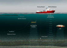
Depth of knowledge: locating the MH370 using towed subsea sleds
Armed with a map of the mountainous subsea terrain that characterises offshore Western Australia, the Fugro Discovery and the GO Phoenix – a supply vessel funded by the Malaysian Government and the Australian Transport Safety Bureau (ATSB) – have already searched more than 6,900km2 of the seafloor using a towed side-scan sonar vehicle.
"Phase one of the operation began in June with the bathymetric survey," explains Luijnenburg. "Up to that point 95% of the search area had been charted using superimposition imagery, similar to that used by Google Earth, which only makes a vague estimate of the seabed and is not advanced enough to conduct a detailed search for aircraft wreckage. For example, we’ve already noticed that there are substantial differences between the actual measured depth and the satellite topography.
"Now that we have the bathymetric map, we can move into the second phase of the search, where we are going to tow an echo-sounding sled unit very close to the seabed – something like 150m – in order to give us the best possible combination of data resolution and swath width.
"The sled will be pulled with a cable attached to the Fugro Discovery and is equipped with a built-in multibeam echo-sounder looking down, two sidescan sonars searching 750m either side of the vehicle, an obstacle avoidance sonar looking forward, cameras and hydrocarbon sniffers," he adds.
The sniffer technology has already proven effective during seismic and reservoir monitoring work for offshore oil and gas operators and fifty or more 100,000km survey operations for the fibre-optic telecoms industry, but is still relatively untested during aircraft recovery projects in uncharted areas.
"We don’t know if the subsea sniffers will work," admits Luijnenburg. "Fugro generally uses them for oil and gas survey work in order to measure background hydrocarbon seepage from the seabed and offshore Western Australia is a totally new area. However, we considered it smart to build them into our survey package because they are capable of sniffing out jet fuel in the water.
The Korean Institute of Ocean Science and Technology has unveiled a subsea crab with six legs designed to survey and inspect subsea structures .
"Unlike an AUV, which needs to be launched, completes its survey and then is recovered so that the data can be downloaded, the sled unit is permanently connected to the vessel via a cable containing power leads and glass-fibre data communications lines," says Luijnenburg. "The daily data gathered by the Equator is shipped to shore in real time and is basically on the client’s desk the next morning."
Twice the expertise: inside the Fugro Equator and Fugro Discovery
The emphasis on state-of-the-art technology extends to the Fugro Equator and the Fugro Discovery. The latter survey vessel arrived in the MH370 underwater search area on 22 October and was joined by the 65m-long Equator a week later after it had completed the bathymetric mapping.
Both vessels have an efficient hull shape, diesel electric drive and rudder propellers to maximise fuel efficiency, navigational control and station keeping capabilities. Conducted vibration is kept to a minimum, resulting in an acoustically quiet platform that enables high-quality data collection.
"Originally, survey vessels were often modified fishing vessels, so Fugro developed custom-built, specialist vessels with a quiet sound signature to avoid disturbance of acoustic signals," says Luijnenburg. "For the bathymetric survey, the Equator used mamo-protection – the system starts up very slowly and quietly to make mammals and dolphins aware that we are going to make noise in the water.
"Increasingly, our standard survey vessels are becoming big data processing computer centres because they employ a number of sensors. The Equator has on board a Kongsberg 302 multibeam system with a range of 7,000m to 10,000m and a suite with five and a half times water depth at 5km. The vessel features focus beam technology for transmission and reception, high-density multiple modes, 64 pings, and, of course, roll pitch and stabilisation," he adds.
The Equator also features industrial grade servers that network and integrate acquisition, navigation, processing, charting and reporting systems, as well as an advanced in-house digital positioning suite.
"In addition to an Applanix OSMB motion sensor on board, the Equator also features a high-accuracy Starfix G2 positioning system," explains Luijnenburg. "This Fugro proprietary digitare GNNS system takes in signals from a number of satellite navigation systems such as GPS, Glonass and the European Gallileo satellite system, and can successfully merge these signals into the best possible position to an accuracy of 5cm to 10cm."
Status report: MH370 and the future of subsea mapping technology
Eight months on from the disappearance of Malaysia Airlines Flight 370, the search effort is focused on the 7th arc, a long, narrow stretch of the Indian Ocean where the aircraft last communicated with a ground station through a satellite and is thought to have run out of fuel. Refinement of the analysis over the coming weeks will prioritise the underwater search area along this arc to 60,000km2.
However, the project continues to be mired in controversy. ATSB, the Australian Government body in charge of coordinating the operation, has been forced to slash twelve percent of its staff due to $2m budget cuts, throwing the future of the search into doubt, while a Malaysian family has filed a lawsuit against the Malaysian Government and Malaysian Airlines.
Against this backdrop, how is the search effort progressing?
"It is our understanding that the Australian Government has budgeted for about a year’s work, should this be needed, and the Australian Prime Minister says they are cautiously optimistic that this is where we can find MH370," he says.
The high-accuracy survey equipment employed by Fugro in the south Indian Ocean, combined with rapid advancements in digital seismic, seabed and sub-seabed mapping technology, is also set to play a defining role in the future of offshore oil and gas E&P operations, as Luijnenburg explains.
"The prime mover for the oil and gas industry nowadays in terms of deepwater surveys is the AUV," he states. "Working with oil and gas companies often means needing to detail stamps on the seabed. What they want is the best data of the seabed, and with multibeam sonars, sub-bottom profilers and more built into AUVs, you can provide what is needed.
"The next thing we see happening is that ROVs will become more capable at that sort of depth. Fugro built standard 2,000m-rated ROVs for its own use and for clients, followed by 3,000m. The next generation will be 4,000m-rated, that’s a no-brainer – a decade ago we thought 3,000m was out of reach, now we consider it halfway routine.
"The future will probably see ROVs and AUVs combined. If you need surveys in large oil and gas fields you will bring an ROV down with an AUV embedded in it. We are very excited about that sort of development."
.gif)
