Modified by time, tide, the physical environment and its chemistry, the movements of an oil spill inevitably require extreme urgency to correctly map its location and extent. The aftermath of a big spill always poses immediate, tactical demands upon the company responsible, particularly in order to effectively deploy countermeasures for an effective response.
Consequently, a high premium exists on systems which can provide a synoptic, wide-field view and that are robust across a range of weather conditions.In the wake of what happened in the Gulf of Mexico, the industry has, predictably, been drawn to review the whole issue of detection technologies, and oil spill response radar in particular has enjoyed significant renewed interest.
Go deeper with GlobalData

Spy in the sky
Conventionally, airborne and satellite radar systems (SLAR and SAR) have been used to measure oil spills, utilising their native high-contrast, high-angle advantage, but the approach is not without its limitations. Although satellite providers have driven down the lead time for re-targeting observations to a given area, ultimately technical and operational parameters dictate that a single pass, single sweep detection technology can only capture a few brief moments in time.
With one of the primary goals of response being the protection of sensitive marine or coastal habitats, modelling the progress and trajectory of the spill slick forms a major component of countermeasure planning and in a potentially fast unfolding scenario, this cries out for near constant data.
Ship-borne solutions
There is a compelling logic to having detection solutions afloat, making use of on-board technology that allows a vessel to track the slick even as it navigates its way towards it.
See Also:
Three companies in particular – Consilium, Rutter and SeaDarQ – have developed products that seem to be successfully establishing the efficacy of the idea on the international stage.
How well do you really know your competitors?
Access the most comprehensive Company Profiles on the market, powered by GlobalData. Save hours of research. Gain competitive edge.

Thank you!
Your download email will arrive shortly
Not ready to buy yet? Download a free sample
We are confident about the unique quality of our Company Profiles. However, we want you to make the most beneficial decision for your business, so we offer a free sample that you can download by submitting the below form
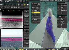
By GlobalDataThe principle behind the approach exploits oil’s natural capacity to smooth the normal roughness of the sea surface and dampen wind-induced capillary waves, leading to a reduction in the intensity of radar back-scatter arriving at the return sensor, and creating a dark signature on the image.
Oil, however, is not the only possible cause of these darker patches; the reduced wind stress of a colder sea surface, algal blooms, sea ice and even the turbulence from a propeller can all produce similar results at times.For each system, the underlying algorithms and interpretive software form an indivisible part of the technology suite and are, obviously, essential in guarding against the risk of false identifications.
Success at sea
The proof of the proverbial pudding is in the eating, and in 2010, the opportunity arose in the shape of the annual ‘Oil at Sea’ exercise, run by the Norwegian Clean Seas Association for Operating Companies (NOFO) in June. Norway is arguably the only country in the world to permit the deliberate discharge of 100 cubic metres of oil to ensure the realism of the test facing clean-up and containment technologies, which was to enable the two participating radar systems – from Consilium and Rutter – to be trialled in some of the most exacting and representative conditions possible.
The systems involved were the Selesmar Selux ST 340 from Consilium, with its add-on software package incorporating state-of-the-art video processing and Rutter’s Sigma S6, equipped with an integrated infrared camera and charting software from the company’s Norwegian partner, Aptomar.
Their task was to detect and track three separate oil-in-water emulsion spills, of 1,200l, 2,400l and 600l respectively, by day and by night, in sea states from 2 to 4 and winds of between 9m/s and 5m/s.
The results were to prove impressive for both of the rival solutions, with detection being achieved at distances of around one nautical mile, and while the test ships were moving.
Unsurprisingly, the market is watching eagerly as further product development continues.
Partners Rutter and Aptomar intend to continue along the path of enhanced integration between their system components, while the NOFO trial results have already led Consilium to develop an innovative interface to present oil slick data directly onto a vessel’s electronic chart display and information system (ECDIS).
It is not just the spectre of another event on the scale of the Deepwater Horizon that haunts the collective consciousness of the industry and makes oil spill detection radar quite so appealing. A system that can function reliably in darkness has many advantages, from ensuring clock-round continuity for spill monitoring, to detecting illegal discharges at night.
Moreover, as the potential riches of the Arctic increasingly beckon – and Exxon Valdez remains a name to contend with – dealing with a spillage event, effectively blind, in that pristine environment in the depths of its dark, polar winter is a nightmare few would wish to contemplate.
It seems radar is the right technology, at just the right time – and that will always make for a powerful combination.