
The offshore oil and gas industry is moving ever further down the road towards the so-called”digital oil field”, developing new software solutions and technologies that allow for more centralised, integrated and accessible data for the complex variables of the offshore environment and the industry’s infrastructure. In the future, this could lead to innovations that allow operators to check on their vital offshore infrastructure, not to mention survey and workforce information, at the touch of a button.
New options are emerging in the field of geographic information systems (GIS) for the offshore industry, especially as the global adoption of high-speed broadband gathers momentum. While some companies offer advanced, custom-built mapping systems, UK-based energy analysis firm Infield Systems has taken a different route.
Go deeper with GlobalData

Discover B2B Marketing That Performs
Combine business intelligence and editorial excellence to reach engaged professionals across 36 leading media platforms.
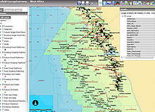
Leveraging the speed and accessibility of high-speed broadband, the company has developed an online, browser-based GIS system called the Offshore EnergyGateway, which allows companies to access data on offshore fields and infrastructure, both existing and in development, from anywhere with a sufficiently fast internet connection, as well as overlay their own data onto the online maps.
Conceived in 2007 and presented in its first incarnation in 2008, the system splits its global maps into 14 separate gateways covering all major offshore oil and gas hotspots. The Offshore EnergyGateway was awarded a”highly commended” prize in ESRI UKs 2010 Innovation Awards. ArcGIS software from ESRI provided the template and server platform for Infield’s system.
As the system is hosted on Infield’s servers rather than needing to be installed with each client, related costs are driven down for both client and provider. But it’s not easy providing this level of detail over the Internet. We talked to Infield’s international sales manager Steve Adams about offering a new kind of online, subscription-based, easily accessible offshore mapping system.
Chris Lo: What you were aiming to achieve with the Offshore EnergyGateway?
Steve Adams: We set up the Infield Offshore EnergyGateway as an easy, online subscription-based mapping and true GIS data package for people to cross-reference text data in a geographical format. This is because text data doesn’t show you the relationship of one line of data to another.
If one oil and gas field or platform is in a block number that runs into the next block, it doesn’t necessarily mean those blocks are next to one another – blocks can be scattered all over the place, especially in places like West Africa.
So we set up the EnergyGateway as a way of geographically front-ending the position of the Infield energy database. You can see where one line of data is in relation to another through a visual mapping system. That’s where it all kicked off, because you can’t cross-reference a spreadsheet.
So we set up the EnergyGateway as an online mapping system that would allow both existing and new clients to have a front-end to their existing subscriptions that would allow them to produce maps and charts without us having to set up mapping systems on their own servers. If there are any problems to the system, we don’t have to go out and service it – it’s all online at Infield.
CL: How long did it take to get all the mapping data for the 14 regional gateways, and how often is the data updated?
SA: It’s taken three years, and it’s still taking place. We update the system monthly, but we could do it daily or weekly. Anything that goes in the text database automatically updates in the map – it’s that quick. The line of text data has a coordinate for all the fields and platforms that we’ve done.
We annotate a symbol, based on certain elements in the data that will automatically import it into the ESRI ArcGIS system. If we put a new line of data in, it will automatically take a symbol based on certain references in that line of data to update the map.
CL: How central was the idea to keep this GIS tool browser-based and available from anywhere, rather than presented as a software package?
SA: Having it installed means you’ve got to sell the company an ESRI licence, which makes it expensive. You’ve got to service it, which means you need dedicated people to go out and service the package. And having the system on a central server where you subscribe to it had never been done before. This is the first true subscription-based package.
There are other oil and gas mapping systems – IHS Energy and Wood Mackenzie have their own systems, but they are incredibly expensive and with the Wood Mac system, you have to install it on a client server, which means you’ve got to maintain it. This is the only one that is a text-driven, online, subscription-based energy GIS system.
CL: Companies can overlay their own data onto the system – how detailed can this overlaid data be?
SA: Any client-specific data can be imported into the EnergyGateway if you’ve got digital latitude and longitude for that line of data. I need to make clear that the EnergyGateway is a reference source to data – it is not a survey package; it is not something that should be used for accurate survey routes.
You can use it for shot lines of surveys where you have the coordinates, but so many different sources are used to make up the locations of the platforms, the licence blocks, either from coordinates where known or drawn conventionally where not known, that there is a certain limitation on accuracy for overlaying as-shot survey lines or route files. It is not a survey package. It is a system that is used for the geographical reference of data, first and foremost.
CL: Could the system be used as part of the tendering process?
SA: The EnergyGateway is a way of quickly showing the relationships of currently operated licences to open licence areas. So someone can quickly zoom in to West Africa, for example, and they’ll be able to see all the Total blocks and which are the open blocks in the surrounding areas. That’s the huge potential of the system.
CL: Infield also provides market modelling and forecasting (OFFPEX) – could you see this service being integrated into the EnergyGateway?
SA: Yes, we could do that. That would be more expensive, but all we would be doing there is we could include our OFFPEX model with the same lines of data used from the basic energy database by inputting it into the EnergyGateway. That would be very straightforward to do.
CL: What other kinds of innovations could we see in the offshore GIS space in the next few years?
SA: We would like to develop the EnergyGateway into a global, online locator for rigs and offshore construction vessels, to provide a weekly log-in where all the global rig and offshore construction vessels are located. That’s something that we’ve actually tried and tested already for rigs.
We also feel there’s a real potential to provide links. For example, if you were reading a news article and you read of a particular field or platform you want to know where it is and what’s around it, you could actually have a worldwide field and platform locator where you could type in the name of the field and platform and it would go straight to that point on a map. So that’s all possible for the future.
CL: How do you think this kind of online GIS could fit into the so-called “digital oil field” of the future, where data is integrated to a much larger degree?
SA: What Infield have developed with the Offshore EnergyGateway is a very good, cost-effective start to doing that, but if you were to look at down-hole reservoir relationships in GIS, then we’re quite a way off. I think you’re talking about very advanced systems that are going to be cost-prohibitive.
If you’re a company looking to start up in South-East Asia and you’re looking to do presentations based on where a new company in the region wants to focus its track record or its future operations, you’re not going to be able to afford those kinds of inter-relationship GIS systems, it would be too costly. As a starting point to electronic GIS mapping, the EnergyGateway is a very good start. It’s not going to be the Rolls Royce, but it will certainly get you on the road.
If we come at this from the perspective of some of the problems we’ve found with subscription-based GIS mapping, the whole system wouldn’t have gotten off the ground if it wasn’t for the advent of high-speed broadband. Without high-speed broadband, online systems wouldn’t work anyway. The greater the broadband access that companies can have in their departments, the better. We went through a major learning curve where companies wanted to subscribe to the system, but they only had a 1MB broadband connection in their department, which isn’t enough to make the system work.
You’re sending huge amounts of raw data backwards and forwards to refresh the screen, so unless you’ve got a minimum of 3MB, building up to 8MB of broadband, any system will not work; it’s too slow. The access feed has limits, believe me. We’ve found plenty of those. This is the big divide, as to whether you have online GIS mapping through subscription through us, or big hefty systems like the Wood Mac and HIS systems, where they have to be loaded on to the company server and serviced. That’s quite a big divide.
