

The Shah Deniz oil field lies between Mobil’s Oquz, Chevron’s Asheron and Exxon’s Nakhchiuan fields. Its name is translated as ‘King’s Sea’.
The prospect is situated in the South Caspian Sea, off the Azerbaijan shore, approximately 70km south-east of Baku. It lies in water depths ranging from 50m in the north-west, to 600m in the south-east. The production sharing agreement (PSA) area covers approximately 860km².
Recommended White Papers
Recommended Buyers Guides
BP, with a share of 25.5% in the project, is the operator. The other PSA partners are StatoilHydro with 25.5%, Socar, LUKOil, TOTAL and NICO with 10% each and TPAO with 9%. The PSA was ratified in October 1996.
In 2010, the Shah Deniz project required $170.4m in operating expenditure and $389.6m in capital expenditure.
Shah Deniz reserves
The Shah Deniz structure lies 35km south-east of the Bahar field and 70km south-west of the supergiant Gunashli-Chirag-Azeri oilfield complex. With a vertical relief of over 1.5km (1 mile), the mapped structure encloses an area in excess of 300km².
The main reservoir rocks within the structure are expected to be at a total depth of 5km to 6.5km and they have been folded into a relatively simple dip-closed anticline structure.
Recoverable reserves for the first stage of development are put at 22.1trn cubic feet of gas and 750m barrels of condensate. Development of the reserves at depths of 600m has been carried out using technology originally developed for the northern North Sea and the Gulf of Mexico.
Seismic studies
In mid-1997, over 22,000km of modern 3D seismic data was acquired about the Shah Deniz PSA contract area by Azerbaijan seismic company Caspian Geophysical. After the data was acquired using the ship MN Baki, Caspian Geophysical processed the information at its centre in Baku.
Subsurface geology
Immediately prior to the 3D data acquisition, additional data was compiled about the water depth and the near-surface conditions over Shah Deniz. This detailed bathymetry provided information on the faults associated with mud diapir collapse, shallow gas, debris flows 1,000m below the seabed and modern-day features such as mud volcanoes and seabed channels.
In total, 12 separate mud volcanoes have been identified. The largest of these, north of the reservoir, produces a major debris flow over 5km wide.
Shah Deniz exploration
Shah Deniz’s first three exploration and appraisal wells (SDX-1, 2 and 3) were started in 1999 and were designed to appraise and delineate the reserves in the northern flank of the field.
They focused on two structures – the Fasila Suite and the Balakhany VIII interval – which form the basis of the field’s first stage of development.
In November 2007, BP announced it had discovered a new, high-pressure reservoir in a deeper structure beneath the northern flank.
The SDX-4 well was drilled to a Caspian-record depth of 7,300m in the southwestern part of Shah Deniz, and tests showed a flow of 35m standard cubic feet per day, with likely reserves similar to if not larger than those in stage one.
This will form the basis of the second stage of development once appraisal over the next few years has delineated this new structure.
In December 2007, BP spudded the first platform-drilled well, SDA-5, which is designed to reach a depth of 7,180m.
Shah Deniz development
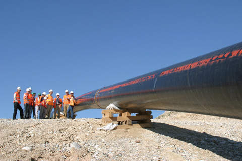
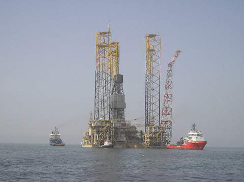
Stage one of the Shah Deniz project includes an upstream and a midstream development. The upstream development consists of a 15 well-slot TPG 500-type production, a drilling and quarters platform installed in 105m of water; three subsea pipelines of 90km each – a 26in pipeline for gas and a 12in pipeline for condensate, and a 4in monoethylene glycol pipeline – from the TPG 500 to the Sangachal terminal in the Azerbaijan capital, Baku; and gas and condensate processing facilities in the onshore terminal.
The midstream development consists of a new gas export system, the South Caucasus Pipeline (SCP), from Azerbaijan through Georgia to the Turkish border. The 690km, 42in SCP has a capacity of about 565bn cubic feet / year and has been built in the same corridor as the 1,760km Baku-Tbilisi-Ceyhan (BTC) oil export pipeline – the second longest in the world. It then links up at the Georgian-Turkish border to a 250km Turkish state-owned BOTAS pipeline that runs to Erzurum, where it enters Turkey’s domestic supply. This stage of production supplies Azerbaijan, Georgia and Turkey.
Stage two of Shah Deniz, known as Shah Deniz Full Field Development, will triple the field’s production. It will involve drilling of up to 30 subsea wells and construction of two offshore production platforms with 16 billion cubic metres per year of gas capacity and 100,000 barrels of condensate capacity.
Production will be routed via 500km of subsea pipelines, which are yet to be built. The South Caucasus pipeline will be extended by 400km to a capacity of over 20 billion cubic metres per year. The Sangachal terminal will also be expanded.
Engineering studies on the full field development are being carried out. First gas from stage 2 is expected in 2016.
Production
Gas and condensate production started in December 2006. In 2007, the field produced a total of about 110bn cubic feet of gas and 0.8m tonnes of condensate. In 2010, the production stood at about 243.6bn cubic feet of gas and 1.9m tonnes of condensate.
As of mid-2008, daily Shah Deniz production stood at about 700m standard cubic feet of gas and about 40,000 barrels of condensate from four wells. Production will increase as new platform-drilled wells are brought on stream later in 2008 and during 2009. Plateau production from stage one will be 317.8bn cubic feet of gas per year and 50,000 barrels of condensate per day.
Financing
Lukoil provided a $180m loan for the project from the European Bank for Reconstruction and Development in 2005. The loan is to be repaid over 12 years.