
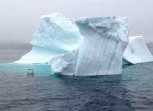

Stretching from the coast of Labrador to the north-east coast of the island of Newfoundland, there is an area known as ‘Iceberg Alley.’ As the name suggests, it is home to numerous icebergs of all shapes and sizes.
Go deeper with GlobalData

Discover B2B Marketing That Performs
Combine business intelligence and editorial excellence to reach engaged professionals across 36 leading media platforms.
Off the coast of Newfoundland, icebergs range from huge tabular formations weighing more than several million tonnes to small ‘bergy’ bits, which are roughly 1m-4m high and 5m-15m wide.
According to IcebergFinder.com, approximately 40,000 medium to large icebergs break off each year in Greenland. Of these, around 400 to 800 drift over towards St John’s, the capital of Newfoundland and Labrador at an average speed of 0.7kph, which is influenced by shape, the currents, waves and wind.
New proposed Arctic-specific rules, unpopular with industry, have created a higher regulatory bar.
Breaking and changing form in unpredictable manners – the danger to those operating within close proximity is obvious, either through a collision, direct hit, or damage to seafloor installations and cables from icebergs scouring the seafloor.
To manage the threat, offshore operators within the area, such as the Hibernia platform, use a special gravity-base structure, reportedly designed to withstand a collision with a one-million ton iceberg and a direct hit from a six-million-ton iceberg. It also uses airborne surveillance data from the US Coast Guard and the Canadian Ice Service.
For smaller packs of ice, ice management teams can use water cannon to break it up or divert it away from the point of interest. However, this is not always possible and vessels may be required to lasso an iceberg with a rope – around 8in in diameter – and navigate around it before slowly moving it off its path.
Predicting the evolution of an iceberg
Before this, of course, the icebergs need to be found. At present, satellites, aeroplanes and ships, as well as tracking beacons dropped onto icebergs, are used, but only provide what might be called a partial picture of its characteristics. This is where autonomous vehicles are entering the picture.
Dr. Ralf Bachmayer of the AOSL explains that there is a requirement for more "in-situ information" – including the size and shape of an iceberg, as well as how it might move and evolve.
The concept of using autonomous vehicles to track the ice came from two areas, he continues: a need and an opportunity. First, the need. "Icebergs pose a threat to marine transportation and offshore operations on the Newfoundland and Labrador shelf," he says.
"Currently they are monitored using satellites, aeroplanes and ships, in order to take action if they are threatening traffic or operations.
"One would like to combine these direct observations with mathematical ocean current models in order to predict the motion and possibly the evolution of individual icebergs," he adds, highlighting that this can be compared to hurricane forecasts, although the majority of an iceberg’s shape is unknown and submerged – making predictions based on surface observations such as satellites troublesome.
Bachmayer, who has worked with commercially available autonomous underwater gliders for more than 12 years, adds that while ships and remotely operated vehicles can be used to perform certain aspects of these tasks, the costs and availability make repeated iceberg observations difficult.
Circumnavigating an iceberg
With an opportunity identified – "none of the existing vehicles had the payload capacity, endurance or robustness we needed to operate in the environment around an iceberg" – Bachmayer and his colleagues at the AOSL set about developing an autonomous observational platform "that is able to stay in the proximity of an iceberg, with the ability to occasionally adjust its relative position to the iceberg and carry a suite of sensors above and below water to monitor meteorological and oceanographic conditions around an iceberg and perform shape measurements."
He continues: "The vehicles use GPS at the surface (for underwater gliders this is only intermittent, since GPS is not available underwater) and magnetic heading in order to determine their position, course and speed. From this information they derive corrections to course and heading if needed in order to achieve the desired location.
"At the same time the vehicles use on-board sensors to avoid collisions with obstacles. In the case of an underwater vehicle, it could be the seafloor, or for a surface craft it could be floating debris."
Russia hosts vast offshore oil and gas resources, estimated to be up to 100 billion mt of oil equivalent.
The plan is for the surface craft to implement the necessary algorithms to autonomously circumnavigate an iceberg, using information from its sensors such as radar, sonar and laser scanners.
One such vehicle that the AOSL is developing is SeaDragon, designed to carry what is known as an integrated data acquisition system that collects data by navigating around its target of interest and generating a multi-dimensional geometric model.
It is expected that this will undergo sea trials this summer, following initial tests within a tank. During its trial it will, according to a paper presented at the Oceans Conference 2014 in St. John’s, carry equipment for both above and below water monitoring, including high resolution cameras and acoustic wave profiling sensors.
Monitoring above and below water
Above water, AOSL’s vehicles will gather and transmit meteorological data, wind speed and direction, air temperature, humidity, barometric pressure and optical and infrared images, as well as laser and radar scans of the surroundings.
The below water measurements include surface wave conditions, water current profiles and sonar scans of the underside of the iceberg, depending on the draft of the iceberg. However, Bachmayer adds that "because of limitations in the communication bandwidth due to power constraints, some of the higher data rate sensors, i.e. imaging and radar, will not be transmitted in real-time."
Nevertheless, getting data to those who need it as quickly as possible is crucial for decision-making, and "will allow offshore operators to make early decisions about the potential risks a particular iceberg poses and allow for actions", Bachmayer adds.
The data will be accessible via a network interface and the unmanned vessel could be "re-tasked" from any platform, offshore platform or supply vessel within the line of sight of the surface craft or from anywhere with a satellite communications connection and the necessary access keys.
Bachmayer continues: "The additional meteorological and oceanographic information gathered by the system can be used also for [a] search and rescue scenario that might need to establish a drift rate and direction for a marine emergency, i.e. man-over-board.
"The size and shape information [of an iceberg] allow[s] for a proper response in terms of how big of a threat the iceberg is and how it can be best dealt with.
"The advantage is that they [autonomous vehicles] potentially could provide focused observations over extended periods of time. This approach has the potential to provide significant cost savings compared to supply vessels, but also [in] the persistent monitoring capabilities compared to aerial surveys."
By collaborating with offshore operators, Bachmayer and his team have been able to refine based on advice and feedback. The AOSL also works with the National Research Council of Canada, which has a database of underwater iceberg shapes.
With offshore assets and icebergs operating in an uneasy alliance, tipping the balance in the favour of man, rather than nature, is an ongoing battle in Iceberg Alley.
However, with the work of Bachmayer and his colleagues, it could be one that is about to get slightly easier.
