
2G Robotics and Sonardyne International have signed an agreement to develop and commercialise a dynamic underwater laser mapping solution designed reduce the duration of seafloor surveys.
Under the collaboration, Sonardyne’s acoustically aided inertial navigation system for underwater vehicles, Sprint-Mapper will be integrated with 2G Robotics’ ULS-500 PRO dynamic underwater laser scanner.
Go deeper with GlobalData

Sonardyne claimed that the projects were carried out in the last six months by combining the 2G Robotics’ scanner with practical positioning accuracy have produced a complete solution for fast laser scanning projects.
Completed projects include archaeological surveys, pipeline and free span inspections, structural integrity monitoring and pipeline metrology.
Sonardyne construction survey global business manager Edward Moller said: “The level of detail visible in the post-processed images we’ve gathered on projects in recent months, has to be seen to be believed; small bolt-holes, individual chain links, marine growth and even painted markings can all be clearly seen.
See Also:
“In terms of wide-area seabed visualisation, it’s a real game-changer.”
How well do you really know your competitors?
Access the most comprehensive Company Profiles on the market, powered by GlobalData. Save hours of research. Gain competitive edge.

Thank you!
Your download email will arrive shortly
Not ready to buy yet? Download a free sample
We are confident about the unique quality of our Company Profiles. However, we want you to make the most beneficial decision for your business, so we offer a free sample that you can download by submitting the below form
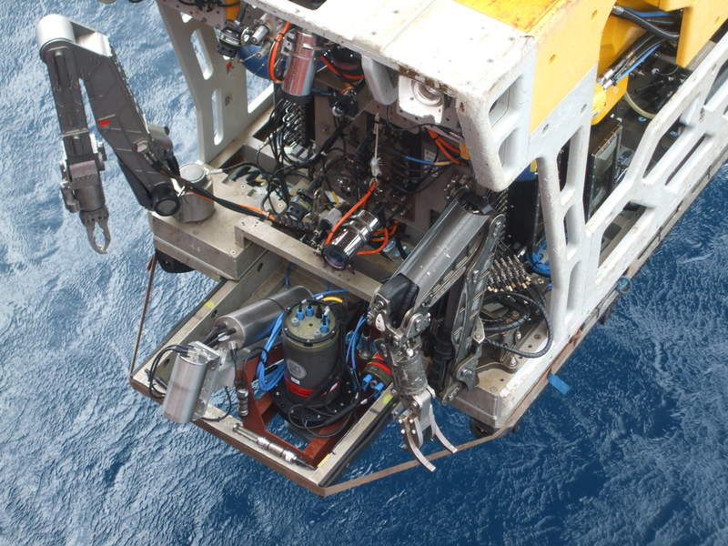
By GlobalDataThe new technique uses the 2G Robotics ULS-500 PRO laser scanner attached to an underwater vehicle that can procure high-density point clouds of subsea assets and environments.
The Sprint-Mapper hardware fitted to the vehicle collects raw acoustic and inertial navigation data as the underground vehicle navigates around the site.
Following the survey, the raw navigational data is post-processed and merged with the laser data to produce a geo-referenced 3D point cloud.
2G Robotics product development manager Chris Gilson said: “This new partnership eliminates the complexities most subsea customers face when integrating multiple systems.
“The detail afforded by the integration of our technologies allows clients to not only capture superior data, but also more effectively compete for projects.”
This initiative will enable underwater mapping quickly and overcome adverse conditions such as visibility.
It will also allow scanning of any target from multiple perspectives as the underwater vehicle need not have to come into contact with the seabed.
Image: An ROV equipped with underwater dynamic laser mapping equipment from 2G Robotics and Sonardyne prepares for its next survey mission. Photo: courtesy of Sonardyne.