

A study by United States Geological Survey (USGS) and NASA has found extensive shoreline loss along heavily oiled areas of Louisiana's coast caused by the 2010 BP Deepwater Horizon oil spill.
The study compared erosion from the oil spill with the coastal changes that happened due to Hurricane Issac in 2012.
Go deeper with GlobalData

Discover B2B Marketing That Performs
Combine business intelligence and editorial excellence to reach engaged professionals across 36 leading media platforms.
Researchers used NASA’s annual mapping to evaluate shoreline loss across most of upper Barataria Bay, situated on the west of Mississippi River Delta.
This study compared the shoreline imagery taken a year before the oil spill and the images taken during a 2.5-year span after the spill.
Researchers found that in the first year after the spill from 2010 to 2011, the pattern changed dramatically and caused widespread erosion throughout the bay.
Erosion rates observed were the most across areas that witnessed heavy to moderate oiling. In the second post-spill year, the high-erosion rate extended even to areas that experienced lower oil spill.
Although some areas were treated to stop this drastic damage from the spill, researchers found no significant difference between treated shorelines with non-treated areas.
In August 2012, after 26-months of the oil spill, Hurricane Isaac directly impacted Barataria Bay.
Erosion rates found within the four-month period after the hurricane were the highest measured by the team.
However, researchers found that although Hurricane Isaac caused more severe erosion in few locations, the land loss from the oil-spill affected a larger area.
USGS geophysicist and lead author of the study Amina Rangoonwala said: “Our study uniquely shows the patterns of shoreline recession seen in Barataria Bay are directly relatable to distinctly different causes.
“There was broadly dispersed erosion due to oiling from the Deepwater Horizon spill and more severe, but localised, erosion from Hurricane Isaac.”
Land lost due to this erosion increased the chances of floods in the area. The coastline may never be replenished again as no new sediments are being formed.
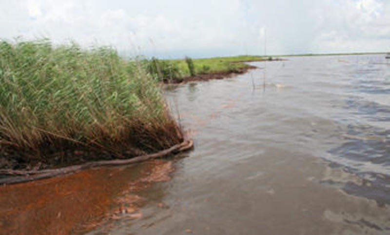
Image: Louisiana shoreline in Barataria Bay during the peak of the Deepwater Horizon oil spill crisis. Photo: courtesy of Bruce A Davis, US Department of Homeland Security.

