
New software developed by scientists at the US Department of Energy’s (DOE’s) National Energy Technology Laboratory (NETL) in the US could help prevent future hydrocarbon leaks and is already providing a much better understanding of how leaks behave in different offshore scenarios, potentially speeding response times to spills if and when they do occur.
Go deeper with GlobalData

The Blowout and Spill Occurrence Model, or BLOSOM, is able to rapidly simulate offshore spills in hypothetical ‘what if’ scenarios, taking into account everything from ocean currents to the volume of the leak, and may also, when used in tandem with other DOE tools, be able to prevent incidents in the future by identifying trends and technology gaps that contribute to a higher risk of spills.
Elly Earls caught up with Kelly Rose, Lawrence Sim, Lucy Romeo, Joe Umhoefer and Jason Vielma, the NETL’s Offshore Integrated Assessment Modelling (IAM) team and the brains behind the technology, to find out more about how BLOSOM works and the impact it could have on future spill prevention efforts.
Elly Earls: Where did the idea for BLOSOM come from?
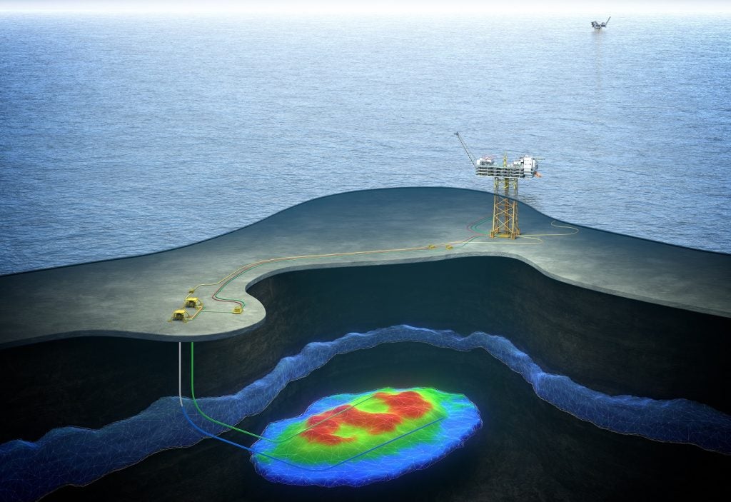
NETL Team: The idea for BLOSOM largely resulted from the DOE’s experience supporting response efforts related to the Deepwater Horizon oil spill (DWH) in 2010. While offshore spills were not new and blowout-sourced spills had occurred before, such as the Ixtoc event in 1979, the DWH event occurred at notable ocean depths of over 5,000ft.
See Also:
During the response to DWH, it was clear that at these extreme conditions many new factors needed to be better understood to ensure more accurate simulation of such spill events, such as gas hydrate formation, the behaviour of subsea dispersants, long-lived underwater oil plumes, and so on. These factors required a new and comprehensive spill model to track the fate and transport of hydrocarbon releases that took into account the explicit 3D nature of the subsea system as well as the sea surface.
How well do you really know your competitors?
Access the most comprehensive Company Profiles on the market, powered by GlobalData. Save hours of research. Gain competitive edge.

Thank you!
Your download email will arrive shortly
Not ready to buy yet? Download a free sample
We are confident about the unique quality of our Company Profiles. However, we want you to make the most beneficial decision for your business, so we offer a free sample that you can download by submitting the below form
By GlobalDataEE: Can you explain in layman’s terms how the tool works to rapidly simulate offshore spills?
NETL: Characteristics like the location, volume and extent of an oil spill are combined with environmental conditions (e.g. ocean currents and wind) to set up a scenario of interest. These scenarios can represent real time simulations for actual scenarios, or hypothetical situations which allows the modeller to evaluate potential risks with different times, places, and situations. BLOSOM then does a numerical simulation of how that situation could be expected to develop by using mathematical representations of the relevant physics and chemistry.
Late last year, Aptomar, together with Transas, announced the creation of the world’s most advanced oil spill combating simulator.
Basically, given ocean currents and hydrodynamic data for a specific region (such as the Gulf of Mexico or the Offshore Arctic or Atlantic Margin), for a given (real or hypothetical) spill origination location, we outline depths, blowout conditions, and seasonal conditions as well as permutations to form our scenarios. Then, by running the simulations, we develop a picture of how these factors influence spill extent and fate to identify risks that could lead to future spill events.
EE: What are the key technology gaps you anticipate addressing with BLOSOM?
NETL: One of the big goals of BLOSOM was to improve information about and the ability to simulate the behaviour of subsurface oil plumes, which was a relatively mysterious subject at the time of the DWH spill. Without forcing it, but using tested and verified physics, we have seen that topic become a major player in our simulations in ways that corroborate the observations made during and after the spill. While there is still much to learn, being able to simulate them with a good degree of confidence can demonstrate whether a potential blowout or response measure will significantly impact the subsurface oil plume and where it will go.
More generally, given a set of locations, we can run a number of simulations and then get a good assessment of which area is potentially at risk, and which type of seasonality/currents would be worst in which to have a blowout (and thus avoid drilling during those conditions).
EE: When it comes to containing spills that have already happened, what impact could BLOSOM have?
NETL: BLOSOM is one component of NETL’s overall Offshore IAM effort. BLOSOM, when coupled with other products of this effort, such as NETL’s Geocube and NETL’s Cumulative Spatial Impact Layers (CSIL) approach, will offer: 1) a seamless spatial analytical tool that predicts the fate and transport of hydrocarbon from a spill (BLOSOM); 2) information and data on environmental and infrastructure resources within the track of that spill trajectory (Geocube); and 3) information on potential impacts and resources relevant to rapid response for mitigation of possible impacts (Geocube & CSIL tool).
By the end of FY15, BLOSOM and the CSIL tool will be integrated into NETL’s Geocube system, offering the ability to rapidly model the spread of the oil over time and the estimated socio-economic and environmental impacts in the oil’s wake. These tools will enable quicker response times, limiting the impact on vulnerable socio-economic and ecological areas.
We can also quickly assess when and how to apply subsea dispersants. As we have seen, dispersant application likely contributed to submerged oil plumes, but in other cases it may delay rapid surfacing and major beaching events. Knowing when and why to apply such measures is of key importance in combating spills.
EE: The plan was initially to use BLOSOM principally to evaluate hypothetical spills and trends in the Gulf of Mexico. In the future, will it be expanded beyond this area?
NETL: The tool is already being used in other areas associated with potential hydrocarbon release events. This expanded use of BLOSOM is largely the result of a project by the Department of Interior’s (DOI’s) Bureau of Safety and Environmental Enforcement (BSEE) [to support spill response planning] that the team was awarded last year, and DOE’s interest in evaluating the offshore Arctic — areas including the Gulf of Alaska and Cook Inlet region, the Salish Sea, offshore of California, and potentially offshore of the North Slope of Alaska. The goal is build BLOSOM to be robust and flexible enough to be used with many ocean models, for any end-user need.
BLOSOM has the ability to simulate offshore spills more or less anywhere. Instead of tying it to a single ocean model it has instead been focused to be flexible and adaptable to many popular and existing hydrodynamic models. We’re already looking at the Puget Sound, the Southern California Bight, and the Gulf of Alaska. Eventually we would like to see it run on the North Slope of Alaska, where drilling could be imminent but threatens a very ecologically sensitive area. That would introduce new challenges, particularly extreme cold weather and sea ice.
EE: Beyond expanding to other areas, what can we expect from BLOSOM in the future?
NETL: With regard to future alternative uses for BLOSOM, with the increase in import and export of hydrocarbons, including natural gas, BLOSOM might be useful for alternative spill risk assessments. This could include scenarios such as oil train derailment risks along domestic water ways, tanker accidents, and so on.
In addition, the recently released DOI report that looked at areas for new offshore exploration and production domestically around the country, raised awareness about offshore E&P activities and concerns. BLOSOM could be used to simulate and assess risks for some of these regions, including the offshore Arctic and the Atlantic Margin. Those simulations could then help decision makers and the public understand the differences between each region.
[When it comes to enhancing the tool] one enhancement currently being discussed relates to simulation in cold weather and sea-ice so we can expand into the Arctic. Meanwhile, we are constantly improving features, re-evaluating equations, validating models and optimising code.Finally, BLOSOM currently works on a desktop environment and can simulate two months’ worth of an oil spill in a day, which is acceptable for spill response. However, to simulate multiple scenarios for research, the simulation time must be greatly decreased. We are developing an extension to BLOSOM that is a high performance code to run an oil spill simulation concurrently on many processors of a supercomputer. This will reduce the simulation time from one day to about 30 minutes.