
An oil spill is a disaster – environmentally, commercially and in PR terms, not to mention the significant danger they can put offshore crew in. BP’s Deepwater Horizon in the Mexican Gulf in 2010, believed to be the worst ever recorded, spilt 210 million gallons of oil into the region over a period of several months. In more recent months, a spill of crude oil off the coast of Brazil has impacted thousands of miles of the country’s north-eastern coastline.
UAVs and what they might mean for the future of spill management
The best way to tackle such events is to respond quickly and effectively. However, doing so is a major challenge for oil companies and other responders. Can the latest technologies help?
Go deeper with GlobalData

Discover B2B Marketing That Performs
Combine business intelligence and editorial excellence to reach engaged professionals across 36 leading media platforms.
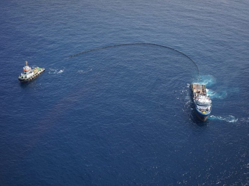
Terra Drone believes it has proven they can. One of its subsidiaries, Terra Drone Angola, says it has successfully demonstrated how drones can be used as a surveillance and reconnaissance tool for oil spill incidents, speeding up the decision-making process in the event of a spill. During the oil spill response exercise conducted by a major oil and gas producer, an oil spill was simulated off the coast of West Africa to assess how drones or unmanned aerial vehicles (UAVs) can be used to quickly collect critical information to relay to responders.
“Environmentally friendly dye was released at the surface of the sea a few hundred meters from the nearest floating production storage and offloading (FPSO) platform using a surfer,” explains Terra Drone Angola’s operations director, Siva Keresnasami. The dye simulated an offshore spill with the aim of demonstrating how UAVs can support response measures.
“We wanted to promote the adoption of UAV technology as a tool to be used to enable effective management and monitoring of actual oil spill incidents,” Keresnasami continued.
An emergency response vessel was positioned a few hundred metres from the simulated spill, onboard was a trained team of UAV pilots operating an octocopter fitted with an RGB camera. Keresnasami says they anticipated one of the biggest challenges, the sun’s glare from the surface of the water, fitting the camera with a polarizing filter to reduce the effect.
What do UAVs have to offer in oil spill management?
The selection of UAV was critically important to the success of the project. The small and often crowded deck of a response vessel renders fixed wing drones unsuitable for this type of mission. Therefore, Vertical Take-Off and Landing (VTOL) UAVs are ideal for this type of scenario. Keresnasami adds UAVs equipped with Extended Visual Line of Sight (EVLOS) or Beyond Visual Line of Sight (BVLOS) capabilities are best suited for this type of work.
EVLOS refers to an unmanned vehicle which can be operated at distance, extending beyond the line of sight of the pilot with so-called spotters relaying its flight information to the controller. BVLOS, an increasingly popular capability, enables flights to go even further. They are controlled by a pilot who is informed about their position, altitude, speed and direction by onboard instruments.
“The plan was to use software to track the flight path of the drone in real-time, while the UAV was used to fly the perimeter of the simulated spill area,” Keresnasami explains.
However, it’s not just the physical structure and onboard capability of a drone that is important: time in the air is critical too. Keresnasami says: “The longer the UAV can stay in the air, the better suited it will be for an oil spill response job. Oil spills can be spread over a large surface area and UAVs used in this application need to have the capacity to be in the air for more than an hour at least.”
During flight the UAV collects data, equipping responders with everything they need to make the right decisions. It can take photos, provide and record live video streams – helpful for post incident analysis – take thermal images, and provide the GPS coordinates necessary to target a response.
“Real-time transmission of videos and GPS coordinates can be incredibly helpful to identify the exact location of a spill so that other vessels with spill containment equipment – such as booms and dispersants – can be directed to the incident location,” Keresnasami says.
During the exercise, six flights were undertaken with the aim of locating and then sizing the spill. In the event of a real spill, this data would have been used to determine the most appropriate response. However, Keresnasami says there is much more UAVs can do: “Drones can also be used to assess the efficacy of spill containment efforts to see how well booms are containing the spill, or how well the dispersants are working to break down the oil sheen.”
The future of UAVs in the oil and gas industry
The use of drones in the oil and gas industry is not new, they have been used to conduct inspections and surveys for some time. However, as technology advances, their application will continue to grow. Keresnasami says he expects to see increased automation, increased onboard processing capabilities, greater integration of artificial intelligence and new payloads (sensors). He also believes there will be less need for human intervention as they become “smarter machines”.
In the simulated scenario, and others like it, just two operators are needed to provide up to 10 hours of flight a day, making the proposition even more attractive as it reduces logistical requirements and therefore costs.
“There is a small window of time where oil slicks and spills can be effectively dispersed,” he concludes. “They can take to the sky quickly to identify the location of the spill, saving a great amount of time.”
The oil and gas exploration community is always looking to reduce risk, but in the event of a spill, having an eye in the sky quickly is one way of managing a response and reducing the impact on the surrounding environment. The success of this simulation might very well herald a new age in emergency response.
