CAD, GIS and Data Management

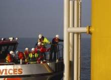
SeaRoc Group’s generate detailed reports on a wide range of information throughout the lifecycle of the project, including construction progress, planned activities and development constraints.
The company’s team of experienced analysts have more than ten years in providing GIS, data management and CAD services to offshore renewables projects.
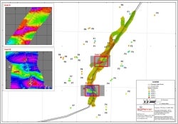
GIS analysis
GIS services allow clients to optimise their data holdings in order to make well-informed decisions throughout the project lifecycle, including:
- Analysis: site selection and constraint, weather window and downtime, data gap and 3D geophysical survey
- Pre-installation and post-installation seabed monitoring
- Asset and vessel positioning based on aspects such as unexploded ordnance (UXOs) and exclusion zones
Data management
SeaRoc effectively manages project data to ensure information is securely recorded, maintained and communicated. The following services can be supplied from the planning stages of a project, through to construction and operations and maintenance.
Database design and management:
- Using a simple and centralised database for effective data storage and access, and implementing a data management strategy from the start of a project to avoid data loss while optimising the value of the client’s data holdings
- Ongoing database maintenance ensures the correct data is readily available to project teams and stakeholders
Mapping
Map production to visualise an array of information, include construction progress, development constraints and planned activities.
CAD services
SeaRoc uses the AutoCAD suite of software in order to meet the client’s CAD requirements (both 2D and 3D). SeaRoc specifically provides a wide range of types of CAD support, including:
- Technical drawings
- 3D design and visualisation
- Concept storyboards and videos
Large amounts of spatial data are generated throughout the project. SeaRoc ensures data integrity and prompt access 24/7 via its online portal, as well as supply PDF maps.
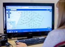
SeaRoc’s WebGIS secure, web-based portal to view project information. The system can be regularly updated with up-to-date information and related reports.